|
LAM SON 719 by Maj. Gen. Nguyen Duy Hinh Published by U.S. Army Center Of Military History
Contents
Glossary
LAM SON 719
CHAPTER II
The Operational Environment
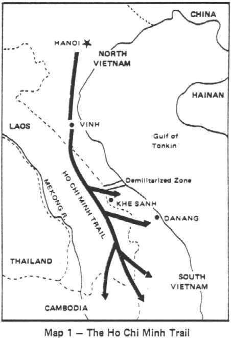
The Ho Chi Minh Trail SystemA byproduct of the First Indochina War, 1946-1954, the footpath system that ran North-South along the Truong Son Mountain Range of Vietnam became known as the Ho Chi Minh Trail; for a long time it had served the strategic purposes of the Viet Minh. From its jungle redoubt of North Vietnam's highlands) the Viet Minh High Command was faced with the pressing need for a secure communication system that would enable it to direct the war effort in South Vietnam and support its subversive activities in neighboring Laos and Cambodia. National Route N÷ 1 which ran parallel to the coastline was not practicable because of French control. Sea routes were available but the risks of running into French naval patrols and foul weather were forbiddingly high. Besides, the Viet Minh did not have a reliable) organized sea transportation fleet. Considering these circumstances, the heavily jungled mountains of the Truong Son Range lent themselves to the establishment of a secure line of communication generally free from observation and attacks.
It was this footpath system that kept the Viet Minh resistance in
South Vietnam alive with fresh troops, weapons and ammunition. By
the end of the First Indochina War, the Ho Chi Minh Trail had been
well developed although it was only a system of jungle paths
connected by local secondary roads and suitable only to movement by
foot, animals and bicycles. Soldiers moved on foot but military
Supplies, although usually carried by manpower, were sometimes
transported on bicycles, oxcarts, horses or elephants. The narrow,
steep pathways meandered
For a time after the Geneva Accords in 1954, the trail was practically abandoned since the war had ended. Then, when South Vietnam, under the leadership of President Ngo Dinh Diem, began restoring its stability and proving that it could stand on its own after repudiating reunification with North Vietnam, the Central Committee of North Vietnam's Communist Party decided on a new course of action against South Vietnam. In May 1959, the North Vietnamese Army (NVA) High Command activated Transportation Group 559 under the direct control of its Rear Service (Logistics) Department. Group 559 was to be a special unit in charge of moving men and supplies into the South for the support of the insurgency effort which had just been initiated under the form of a "war of liberation." The trail's old pathways were rehabilitated and widened, and new ones were surveyed and projected. Group 559's task of enlarging this strategic axis of infiltration was pushed ahead with vigor and determination. The increase of subversive activities against South Vietnam was in almost direct proportion to the development of the Ho Chi Minh Trail, since the Communist war effort in the South was largely sustained by a constant flow of cadre and troops from the North. At this early stage, the flow was sporadic because the journey was harsh and long for the men and the means of transporting supplies still primitive. But as pathways were eventually enlarged into roads, the means of transportation were also improved. Prior to 1965, the Ho Chi Minh system was close to the Vietnam border, but after the United States became involved in the war and bombings increased, the Communists gradually shifted toward the west where they found the densely jungled areas of lower Laos and eastern Cambodia perfect sanctuaries for the movement or concentration of troops and the storage of weapons and war materiels.
To protect the corridor, the Communists established an elaborate defense and security system. The duty of Pathet Lao units was to intensify guerrilla activities and launch periodic attacks in order to keep the Royal Lao Army confined to the cities and towns along the Mekong River. The protection of the trail system and storage areas was performed by Group 559 itself. Augmented by infantry units and unattached militiamen, the group defense forces included anti-aircraft units armed with all types of light and heavy weapons, from 12.7-mm, 14.5-mm and 23-mm heavy machineguns to 37-mm, 57-mm and 100-mm anti-aircraft cannons.
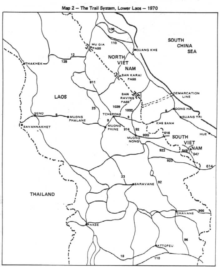
Group 559 installed a forward headquarters in the southern
panhandle of North Vietnam from where it controlled many 'binh
trams' (literally troop stations). In 1970 there were about 40
such stations, from Vinh to the Cambodian border, under the control
of a number of intermediary headquarters. Each binh tram was a
self contained, logistical complex
During the cessation of bombings in North Vietnam, trucks moved by convoy from Vinh down the trail. Upon reaching the Laotian border, they formed units of five to eight vehicles and usually moved only at night or in foul weather in order to avoid the round the clock bombing by United States Air Force planes. As a result, binh trams were usually separated from one another by a day's journey and their parking areas were scattered and well concealed. The vehicles moving on the trail only transported supplies and heavy materials. Light equipment was either carried on men's backs or by animals. Since troops had to march, they moved by day or night, using pathways different from those used by trucks. New recruits or replacements usually entered the system at Vinh in North Vietnam and often marched over 100 days to reach their final destination in South Vietnam. In view of this long journey, they had to rest and recuperate at way stations where they received food, medicine and indoctrinations. Combat units usually moved by battalions of 500- 600 men each and they often suffered substantial losses from disease and constant bombings by the U.S. Air Forc©
During the period from 1960 to 1965, as the fighting escalated, the GVN was unable to do anything against the Laos infiltration route but the United States made a significant contribution in 1961 when it helped organize the highlands Montagnards into combat units (CIDG's) and develop the Vietnamese Special Forces for the defense of the border areas. Against Communist activities on the Ho Chi Minh trail, however, neither the U.S. Army Special Forces nor their Vietnamese counterparts ever interdicted the Communist logistics system to a significant degree, even during the period of maximum effort. Also, the idea of building the "McNamara Line" of sensors across the Truong Son mountain range at the southern boundary of the DMZ was never fully implemented as planned. The surveillance and interdiction of the trail, therefore, lay primarily in the hands of the U.S. Air Force whose reconnaissance planes covered the trail system around the clock. Ground electronic sensors planted along jungle pathways, river crossings, and mountain passes picked up vehicle and other man made noises, transmitted them to over flying planes which relayed the information to terminal stations to be analyzed and interpreted. The electronic monitoring of enemy activities on the trail system helped record the number of vehicles and men moving along the trail; consequently, intelligence on Communist infiltration was remarkably reliable.
In addition to surveillance, a major task for the United States
Air Force was to interdict this infiltration. All types of
aircraft were used including B-52 strategic bombers, sophisticated
fighter-bombers and several types of gun ships. The U.S. Air Force
claimed that its bombs and improved weapons systems inflicted heavy
losses to the enemy in terms of personnel, vehicles and materiel
moving down the
Among the targets of intensive bombing were the mountain passes and roads which were pounded day and night. The enemy's efforts to repair the damage were complicated by his lack of heavy machinery, but he was resilient and stubborn. No sooner was a mountain road destroyed than a detour was completed.
At the beginning of 1970, the enemy's plan to rehabilitate Route
1036 was suspended for some time due to extensive United States
bombing along the Laotian border. Nevertheless, he succeeded in
opening Route 1039 through the Ban Raving Pass which connected with
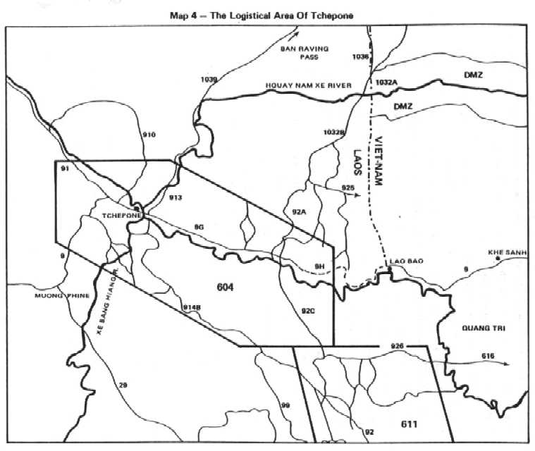
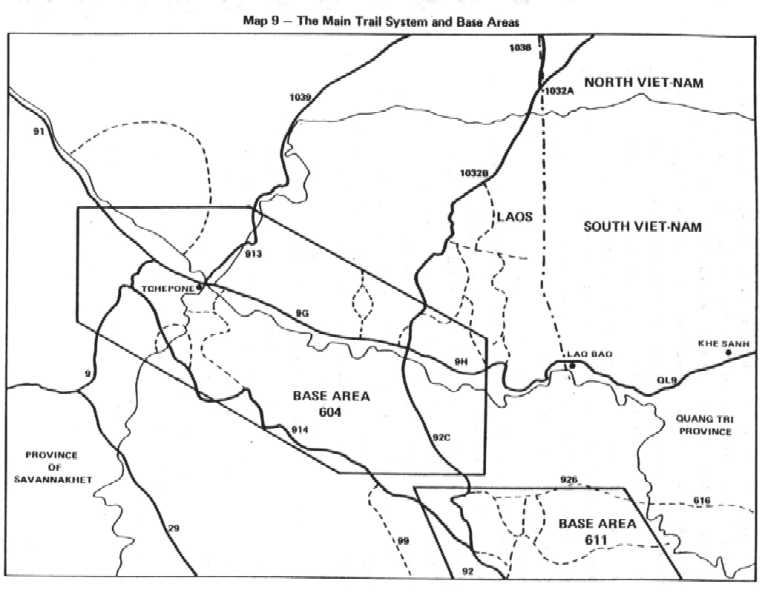
Route 913. This gave the enemy an additional route into Tchepone,
the communications center for base area 604. In the meantime,
Route 1032A in North Vietnam
To the south, the enemy had already completed Route 616 which cut across the Xepon River and deep into South Vietnam. The existence of this east-west infiltration route was detected for the first time on 1 January 1970 but subsequent surveillance indicated that enemy activities on it were light. The heaviest traffic was always reported on the north-south axis, moving from base area 604 on Routes 96, 926 and 914 toward base area 611. By January 1971, Route 1032A had been connected with Route 1032B which gave the enemy an additional roadway into lower Laos from North Vietnam. Recordings made by electronic sensors indicated that of every four trucks leaving North Vietnam, one always moved on this route regardless of the bombings by United States planes west of the DMZ. Aerial photos also revealed that the enemy had built several alternate bypass routes in this area in order to avoid concentrated bombings and ensure the flow of traffic. Reconnaissance planes further reported that east-west Route 925 had been widened but terminated approximately two and a half miles from the GVN border. This appeared to indicate that the enemy wanted to project another infiltration route into the Khe Sanh area, west of Quang Tri but subsequent air reconnaissance showed that the enemy was using Route 616 for truck traffic and his activities were increasing substantially south of base area 611.
All of these indications clearly confirmed the enemy's efforts to
open additional infiltration roads, develop storage areas,
transhipment points and truck parks, and to make the entire area
just west of Quang Tri Province an intricate logistical and
transportation complex complete with pipelines and bypass roads.
Furthermore, all these activities progressed with little
interruption despite continuous bombings. The efforts were most
conspicuous in base areas 604 and 611. On the other hand, to
increase his protection capabilities, the enemy also moved
additional anti-aircraft and combat units into these areas.
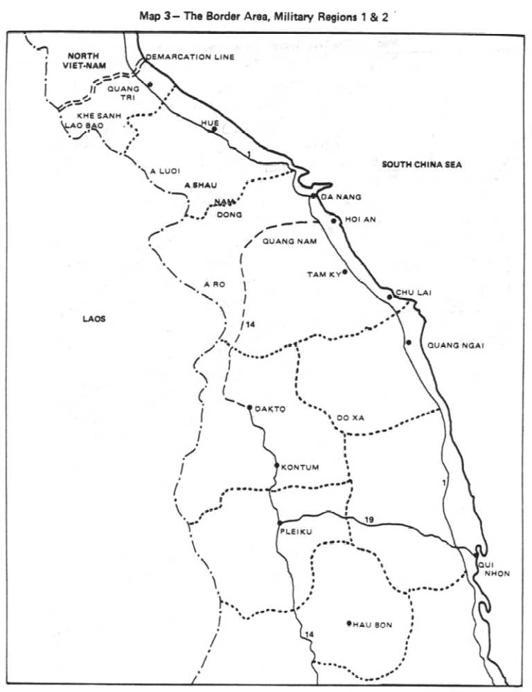
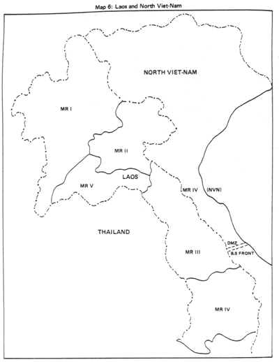
Enemy Situation in Northern Military Region IIn South Vietnam proper, no significant enemy activities were recorded in northern MR-1 during the entire first half of 1970. Enemy initiatives in this area consisted only of attacks by fire and small scale, sapper attacks. Targets were usually remote, small size fire support bases and outposts. The enemy main force units devoted this entire period to building roads, refitting troops, and storing food and supplies, but intelligence reports revealed that enemy forces were preparing to launch an offensive campaign against the two northernmost provinces of MR-1, probably in January 1971. Another agent's report disclosed that North Vietnam might strike forcefully into Quang Tri and Thua Thien during the spring and summer of 1971 with a goal to occupy the plains area of these two provinces. At the boundary area between Quang Tri and Thua Thien provinces, the enemy had further extended the newly rehabilitated Route 616 into the Da Krong River valley, apparently with a view to facilitate his supply movements into MR-1.
In the enemy Tri-Thien-Hue Military' Region, the enemy main force
consisted of three regiments under direct control of the MR
headquarters - Regiments 4, 5, and 6 - and a number of sapper
battalions which usually operated within the MR and sometimes
penetrated into the plains area of Thua Thien Province to interdict
traffic on National Route N÷ 1. In addition, west of Thua Thien
and in base area 611, the 324B NVA Division, supported by the 675th
Artillery Regiment, was almost always deployed with its three
infantry regiments, the 812th, 803d, and 29th.
Enemy Situation in the Laos Panhandle
Air reconnaissance and agent reports further confirmed the enemy's stepped up logistical activities and augmentation of combat forces at base areas 604 and 611 since the beginning of the lower Laos dry season. In October, 1970, an agent report revealed that a division size unit, approximately 10,000 strong, was leaving the Mu Gia Pass and moving south. It was believed at that time that this was the 320th NVA Division with its three organic regiments, the 48th, 52d, and 64th. Subsequent intelligence reports confirmed that the 52d Regiment was located west of the DMZ and the 64th Regiment was building roads in Quang Binh Province, north of the DMZ. It was, therefore, probable that the 48th Regiment was the unit which was moving into base area 604.(2)
In late December, 1970, aerial photography and air reconnaissance revealed an enemy effort to open Route 616 to vehicle traffic. This road appeared to head toward the Laotian salient, west of Quang Tri where the 812th Regiment, NVA 324B Division was reported. In this same area, the enemy was also increasing his logistical efforts and probably his engineer, logistical and anti-aircraft capabilities. Other intelligence data obtained from prisoners of war and an enemy cadre who had rallied to the Royal Lao Army indicated that the 141st and 9th Regiments (separate) were also operating in lower Laos under control of the Communist Southern Laotian Front. It was probable that the 141st Regiment would move back to Quang Nam after being refitted. In the meantime, the enemy 2d Division seemed to be going through a refitting process with its two regiments, the 1st and 3d, in an area north of base area 612. This division was probably preparing to return to Quang Tin and Quang Ngai Provinces in southern MR-1, but it was possible for it to be deployed as reinforcement to the Tchepone area in Laos if required. (4)
In addition to Communist combat units reported in the proposed
operational area west of Quang Tri Province or in its vicinities,
there were eight binh trams that had been recently reinforced with
approximately 20 anti-aircraft battalions
(5). Not all of these battalions were fully equipped but since
each battalion could have from 2 to 16 anti-aircraft
In summary, enemy forces in the area of operation were estimated at three infantry regiments (Regiments 48/320, 243/304, and 812/324B), an artillery element and the binh tram units whose most important capability was anti-aircraft. Total enemy strength in the area was estimated at 22,000 to include 7,000 NVA combat troops, 10,000 men belonging to logistic units, and 5,000 Pathet Lao soldiers (Map 7). The enemy's capability to reinforce within a short time (2 weeks) was estimated at eight regiments which were: the 52d and 64th Regiments of the 320th Division, the 29th and 803d Regiments of the 324B Division, the 3d and 1st Regiments of the 2d Division, and the 141st and 9th Separate Regiments, all supported by artillery elements. Additionally, enemy reinforcement capabilities from North Vietnam were also considered by planning staffs and field commanders. Finally, in January 1971, agent reports disclosed that Communist units located north of the DMZ had received alert orders. The enemy B-5 front was reported making preparations to face an attack by allied forces against the provinces of southern North Vietnam. Remembering his losses during the Cambodia incursion of the previous year, it appeared that the enemy was consolidating his general defensive posture, and would devote particular attention to the security of his infiltration and supply corridor in lower La08 during the remaining months of the 1971 dry season.
The Area of Operation
The vegetation of Quang Tri province reflected the characteristics of these three geographical regions. The flat coastal plains were usually inundated, which permitted rice planting and the agglomeration of farming villages. The piedmont region was dry and sterile with vegetation not taller than a man's height, consisting mostly of scattered bushes. The mountainous region was generally covered by rain forests whose trees grew taller further to the west. These were double and triple canopied forests with very dense undergrowth consisting mostly of bamboo and thorny under- bushes. River valleys in this region were fertile and favored crop planting. The Lao Bao Valley, for example, was renowned for its coffee and fruit trees. The primary line of communication (LOC) in the province was National Route N÷ 1 which ran north-south close to the coastal plains. A secondary LOC was National Route N÷ 9 which ran from a junction with Route N÷ 1 in the vicinity of Dong Ha west to the Laotian border. From Dong Ha to Son Lam hamlet (close to FSB Vandegrift), Route N÷ 9 was a two lane, all weather, hard surfaced road, occasionally subjected to enemy harassment. West of FSB Vandegrift it became a dirt road usable only in good weather; this stretch was insecure and had several destroyed bridges. The Khe Sanh airfield, which had been abandoned for a long time, would require extensive repairs to be operational. The Thach Ran River, a major tributary of the Cua Viet River, was a major waterway linking the cities of Quang Tri and Dong Ha with the seŐ Because of its proximity to the DMZ, this river was continually a target for minings and sabotage by enemy frogmen.
To the west beyond the Laotian border, the terrain was
predominantly mountainous. The area of operation on this side of
the border was
The second prominent terrain feature was the Co Roc Highland adjacent to the Laotian border and just south of Route N÷ 9. This highland had several peaks with elevations ranging from 500 to 850 meters which dominated Route N÷ 9 to the east and west. It also provided excellent observation into the Khe Sanh areŐ The vegetation in the Co Roc area consisted primarily of bamboo and brushwood, offering adequate cover and concealment. The third significant terrain feature was a high escarpment whose ridgeline extended all the way to Tchepone, parallel to and south of Route N÷ 9 and the Xepon River. Several peaks of this ridgeline were 600 to 700 meters high and offered excellent observation over Route N÷ 9 and the Tchepone areŐ Much of the area was covered by dense jungle and thick brushwood except for a few places which had been cleared for farming. The terrain north of Route N÷ 9 was hilly and heavily vegetated against a backdrop of relatively high peaks which restricted operations in this area almost entirely to infantry. Around Tchepone, the terrain was much lower, sparsely vegetated and more appropriate for armor vehicles. Route N÷ 9 from Khe Sanh to Tchepone was a one lane, unevenly surfaced dirt road with destroyed bridges and culverts. Dominated by the high escarpment to the south, this road was easily interdicted. It also was difficult to prepare bypasses due to the river to the south and the hilly terrain to the north.
February in the Tchepone area was the transitional period from the northeast to the southwest monsoons. The northeast monsoon, which brought rains and cloudiness to Central Vietnam above the Hai Van Pass from October to March, was the dominant weather factor. The Truong Son mountain range deflected much of this wet weather on the Laotian side but in the area of operation, the skies were generally covered. The amount of cumulus buildup in this area depended on the strength and depth of the monsoon. Average temperature during February was 220C in the lowlands and about 180C in mountainous regions. As of mid March, the southwest monsoon gradually picked up, resulting in a relative improvement of the weather and higher ceilings. The average temperature was warmer than in February but this was a period of showers during which the skies were temporarily covered. Beginning in May, however, rainfall became heavier over the Truong Son Range while in the eastern lowlands, the weather was dry and hot.
In general, during the period considered for the operation, the
weather was fairly good but quite unpredictable. From experience,
it was estimated that the area of operations would be cloudy and
hazy in the morning. The weather was favorable for air operations
only from 1000-1200 hours until mid afternoon. The 2,500-foot
ceiling in the low lands would allow only a l,000-foot altitude' in
the area of operation. This was recognized as a major handicap
since all aircraft used in support missions would be located in the
lowlands and would have to be
(1)"Untold Story of the Ho Chi Minh Trail", U.S. News and World Report, February 15, 1971. (2)All enemy units referred to in this monograph are infantry unless otherwise specified. (3)U.S. XXIV Corps Operation Order, LAM SON 719, dated 23 January 1971, Annex B (Intelligence), p. B-5. (4)No distinction is made here between NVA and Viet Cong units because it does not make sense to dwell on this technicality when 3/4 of the so called Viet Cong units were made up of NVA troops and the majority of their commanders and staffs were North Vietnamese. (5)U.S. XXIV Corps Operation Order, LAM SON 719 dated 23 January 1971, Annex B (Intelligence): Appendix 2 (Anti-Aircraft Capability), p. B-2-1.
|